
PL-300 · Question #195
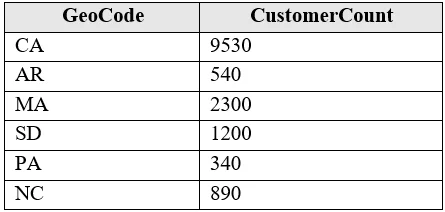
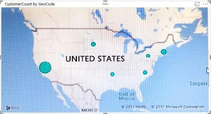
You have the following table named Location. The GeoCode column represents the country where each customer is located. You create a map visualization as shown in the exhibit. (Click the Exhibit…
The correct answer is B. Change the name of the GeoCode column to Country. Power BI uses column names as hints to automatically assign geographic data categories. When a column is named 'Country', Power BI recognizes it as country-level geographic data and correctly places pins on the map. The column 'GeoCode' is ambiguous - Power BI does not…
Question
You have the following table named Location. The GeoCode column represents the country where each customer is located. You create a map visualization as shown in the exhibit. (Click the Exhibit tab.) You need to ensure that the map displays the country locations. What should you do?
Exhibits
Options
- AReplace the values in the GeoCode column with postal codes or zip codes.
- BChange the name of the GeoCode column to Country.
- CChange the name of the Location table to Country.
- DChange the Default Summarization of the GeoCode column.
- EAdd a Geoportal column to the Location table.
- FChange the Data Type of the GeoCode column.
How the community answered
(30 responses)- A3% (1)
- B93% (28)
- E3% (1)
Explanation
Power BI uses column names as hints to automatically assign geographic data categories. When a column is named 'Country', Power BI recognizes it as country-level geographic data and correctly places pins on the map. The column 'GeoCode' is ambiguous - Power BI does not automatically know it contains country identifiers. Renaming it to 'Country' tells Power BI to categorize the data as a country geography, enabling the map visualization to resolve and display the correct locations. Changing the data type alone (option F) would not give Power BI the geographic context it needs without also setting the Data Category.
Topics
Community Discussion
No community discussion yet for this question.