Esri
EADP10 · Question #86
EADP10 Question #86: Real Exam Question with Answer & Explanation
Sign in or unlock EADP10 to reveal the answer and full explanation for question #86. The question stem and answer options stay visible for context.
Question
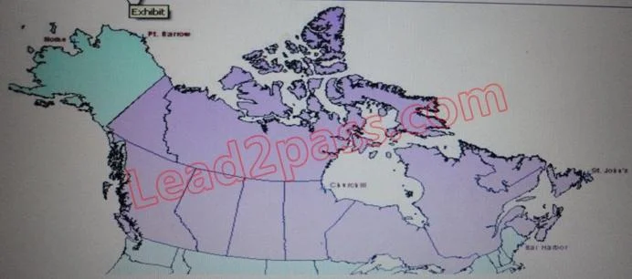
Refer to the exhibit. The ArcGIS user is given data for the Arctic, and is asked to perform various types of analysis using the data. The data extends from the North Pole south to 55 degrees North Latitude Data layers may contain points lines, or polygons and include ice surveys from NOAA depth contours; continental margins, locations of known and suspected oil reserves, endangered species habitat and territorial boundaries for nations having Arctic coastline. An ArcGIS user is asked to calculate the distance a cruise ship will travel through open water, departing from Nome, Alaska, with stops at Point Barrow Alaska Churchill Manitoba St John's Newfoundland and ending in Bar Harbor Maine. On the basis of these calculations the cruise ship line will determine fuel requirements and travel time. Which map projection yields the most accurate results for this distance calculation? Esri EADP10 Exam
Exhibit
Options
- AAlbers equal area conic
- BLambert azimuthal
- CMercator
- Dazimuthal equidistant
Unlock EADP10 to see the answer
You've previewed enough free EADP10 questions. Unlock EADP10 for full answers, explanations, the timed quiz mode, progress tracking, and the master PDF. Question stem and options stay visible so you can still see what's on the exam.